NEWS AGENCY KASHMIR NEWS TRUST #KNT
© News Agency KNT. Republishing or reproduction of this content in full or part without permission or proper attribution is prohibited.
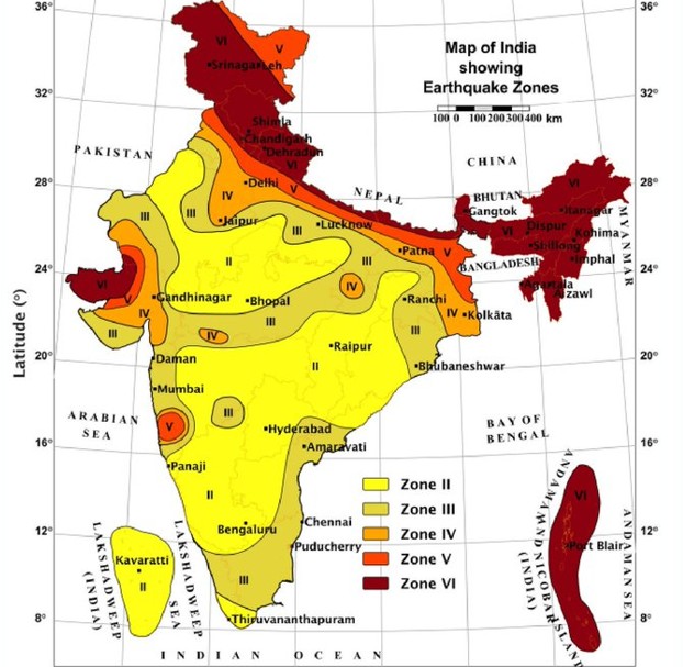
Srinagar, April 1, KNT: Jammu and Kashmir continues to fall in one of the highest earthquake risk categories in India, with the latest seismic zonation map placing much of the region in Zone V, the most vulnerable category, officials and experts said.
The updated map reaffirms that the Himalayan belt, including Kashmir, remains highly prone to major earthquakes due to active tectonic movements along the Indian and Eurasian plate boundary.
The development is significant as it highlights persistent seismic vulnerability in the region, underscoring the need for strict adherence to earthquake-resistant construction and disaster preparedness measures.
The concern is reinforced by the memory of the devastating 2005 Kashmir earthquake, one of the deadliest earthquakes in the region’s history.
The 7.6 magnitude quake struck on October 8, 2005, with its epicentre near Muzaffarabad, causing massive destruction across Pakistan-held Kashmir and parts of Jammu and Kashmir, including Uri and Tangdhar.
Scores of people were killed, infrastructure was flattened, and entire villages were destroyed, highlighting the region’s extreme vulnerability to seismic activity.
Read Also: Qualities of a True Believer According to the Quran
Experts say the 2005 disaster remains a critical reference point for assessing earthquake preparedness in Kashmir.
According to geologists, Kashmir lies in a seismically active zone due to continuous collision between tectonic plates, making it susceptible to high-intensity tremors.
The latest map categorises Indian regions into seismic zones ranging from Zone II (low risk) to Zone V (very high risk), with Kashmir firmly placed in the top risk bracket.
While parts of central and southern India fall under lower-risk zones, northern states, particularly those in the Himalayan region, remain exposed to severe earthquake hazards.
Officials said the zonation map is based on seismic history, geological structures and fault line activity, and serves as a guideline for urban planning and construction norms.
Authorities require stricter building codes in high-risk zones like Kashmir, but experts have repeatedly flagged gaps in enforcement and compliance.
Unregulated construction and rapid urbanisation in parts of the Valley have raised concerns about the potential impact of a major earthquake.
Disaster management officials have stressed the need for regular mock drills, public awareness campaigns and strengthening of emergency response systems.
The updated seismic map is expected to guide future policy decisions and infrastructure planning in Jammu and Kashmir.
An official that while earthquakes cannot be predicted, preparedness and mitigation measures can significantly reduce loss of life and property.
The renewed focus on Kashmir’s seismic risk comes as authorities continue to evaluate disaster readiness in one of the most sensitive geological zones in the country. [KNT]